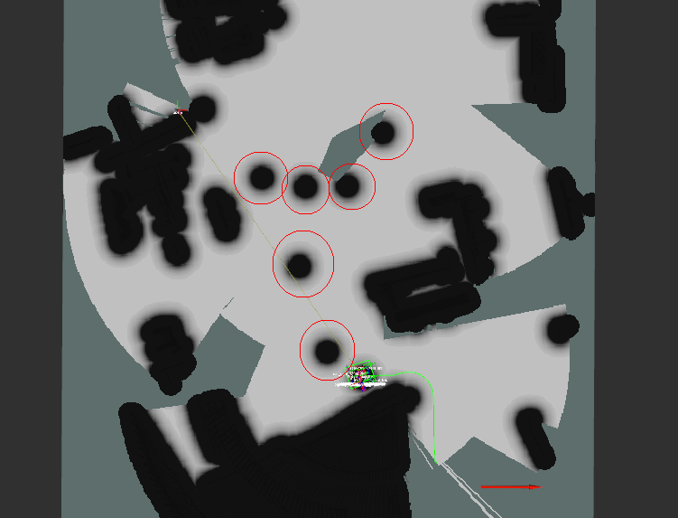
I am trying to use a SLAM package along with the ROS navigation stack and a package called explore_lite, which automatically directs the robot towards unexplored areas. I have most of this working, but I've noticed that the robot's initial position, as well as certain locations it has been in, will be marked as obstacles in the costmap, even though the only thing which has been in the location marked is the robot itself. This can be seen in the below image, where the red circles are made around 'obstacles' placed at previous positions of the robot.
Does anyone know why this is happening? I've tried changing my costmap parameters, and I've even set footprint_clearing_enabled to true for my global costmap, but I can't figure this out.
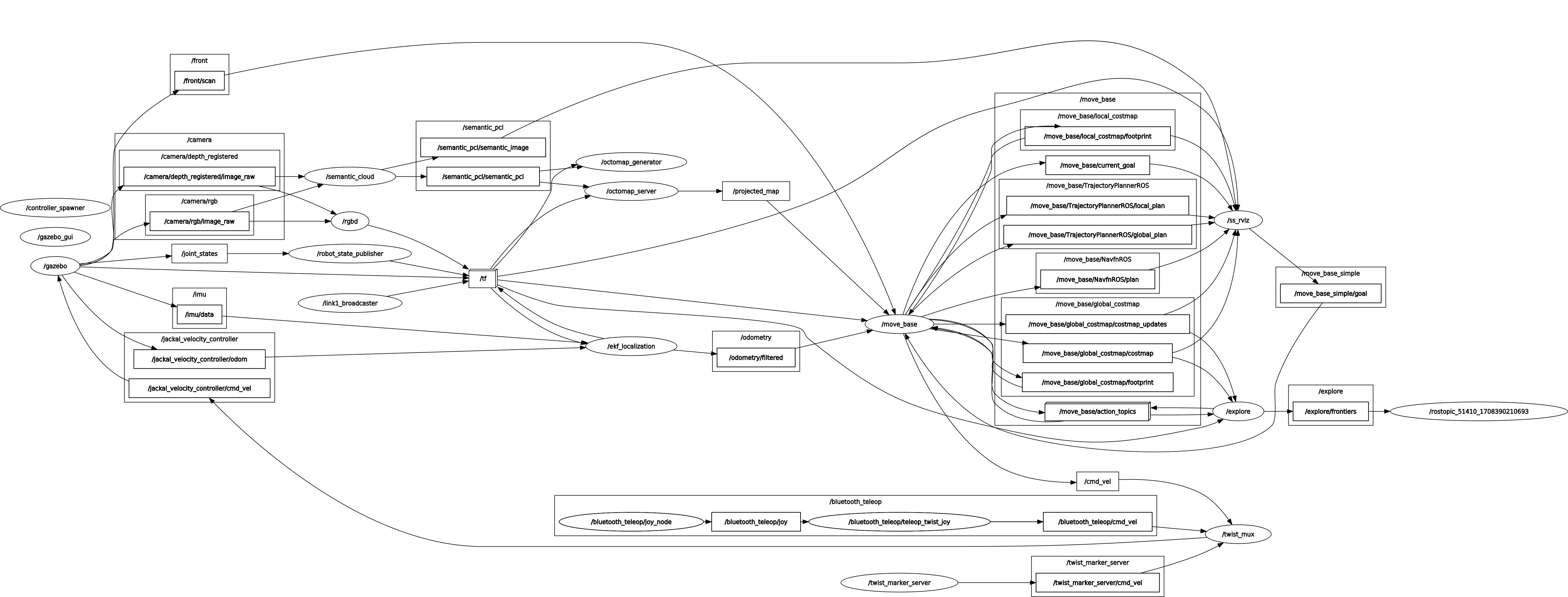
rqt graph
costmap_common_params.yaml
obstacle_range: 2.5
raytrace_range: 3

# found using https://answers.ros.org/question/385798/how-can-i-find-the-appropriate-robot-footprint + jackal dimensions
footprint: [[-0.215, -0.254], [0.215, -0.254], [0.215, 0.254], [-0.215, 0.254]]

inflation_radius: 0.5
transform_tolerance: 1

controller_patience: 2.0

NavfnROS:
    allow_unknown: true

recovery_behaviors: [
    {name: conservative_clear, type: clear_costmap_recovery/ClearCostmapRecovery},
    {name: aggressive_clear, type: clear_costmap_recovery/ClearCostmapRecovery}
]

conservative_clear:
    reset_distance: 3.00

aggressive_clear:
    reset_distance: 1.84

observation_sources: laser_scan_sensor
laser_scan_sensor: {sensor_frame: front_laser, data_type: LaserScan, topic: front/scan, marking: true, clearing: true}
global_costmap_params.yaml
global_costmap:

  # world? -> odom now, see tf issue fix
  global_frame: map

  # check this on Jackal tf
  robot_base_frame: base_link

  update_frequency: 5.0
  publish_frequency: 2.0

  map_type: costmap

  # false since even though the map is from map_server it's on a topic and not already saved -> rtab says true?
  static_map: true

  plugins:
  - {name: static,               type: "costmap_2d::StaticLayer"}
  - {name: obstacles,            type: "costmap_2d::ObstacleLayer"}
  - {name: inflation,            type: "costmap_2d::InflationLayer"}

  obstacles:

    track_unknown_space: true
    footprint_clearing_enabled: true
local_costmap_params.yaml
local_costmap:

  # (not map, see https://robotics.stackexchange.com/questions/44925/running-move-base-for-navigation-via-gmapping)
  global_frame: odom
  robot_base_frame: base_link

  update_frequency: 5.0
  publish_frequency: 2.0

  static_map: false
  rolling_window: true

  width: 6.0
  height: 6.0
  resolution: 0.025

  # ?
  origin_x: 0.0
  origin_y: 0.0

  map_type: costmap

  observation_sources: laser_scan_sensor
  laser_scan_sensor: {sensor_frame: front_laser, data_type: LaserScan, topic: front/scan, marking: true, clearing: true}
EDIT 1- I don't know if this changes anything, but this is the pipeline I am using- I am using a semantic SLAM package (https://github.com/floatlazer/semantic_slam) which builds an Octomap using input from an RGB-D camera. The robot is localized using ORB-SLAM2. I then use a projection of the Octomap as an occupancy grid, which I feed into the navigation stack to create the costmaps.
However, even though the 'obstacles' show up in the global costmap, they are not present in the occupancy grid used to make the costmap or the local costmap.
EDIT 2- Here is a video of the robot- https://streamable.com/jeag6e. I am simulating it in Gazebo, and I have both an occupancy grid and the global costmap turned on. The shapes seen in the black of the costmap are shapes in the environment from the occupancy grid, and the robot is being directed by explore_lite as previously mentioned.

